Scientists have scanned a section of the North Atlantic and revealed the remnants of what had been a huge pulse of hot rock that initiated a rapid climate warming event 56 million years ago.
The climate event, known as the Paleocene-Eocene Thermal Maximum (PETM), warmed the already-hot climate of the time by about 5.6° C due to a jump in atmospheric CO2. Levels of that greenhouse gas rose from about 1,120 parts per million to about 2,020 ppm—much higher than today’s 417 ppm. Although it didn’t trigger a major extinction, it still exterminated some deep-sea creatures and tropical plants. Scientists want to understand the PETM better, because it’s an example of how the Earth reacted to a rapid rise in atmospheric CO2 a bit like we’re currently experiencing, albeit starting from a hot, ice-free climate.
Finding a cause
Although the cause of PETM has been debated since it was discovered in the 1990s, more and more evidence has accumulated that points to massive quantities of CO2 and methane emitted due to volcanic activity in the North Atlantic as the primary cause. This activity created what’s now known as the North Atlantic Igneous Province— the same kind of enormous volcanic phenomenon linked to climate disruption and extinctions at other times in Earth’s past, like the end-Triassic, the end-Permian, the early Jurassic, and others.
But there’s a problem with that explanation. The jump in temperatures at the start of the PETM took between 3,000 and 10,000 years, whereas the igneous activity lasted far longer, from about 63 to 54 million years ago. If the volcanic activity was responsible for the PETM, then something extraordinary must have happened at the time of the warming to distinguish it from the volcanism that preceded and followed. That extraordinary event seems to have been a geologically quick surge of magma that invaded oil-rich sediments and boiled off CO2 and methane. A paper published in 2019 showed how a huge pulse of hot mantle rock from a “mantle plume” could have supplied that magma as it spread out beneath the crust.
In December, at the fall meeting of the American Geophysical Union in Chicago, the same team of scientists behind the 2019 paper presented preliminary evidence that there had been a huge pulse of hot mantle rock, based on what it left behind in the North Atlantic.

“The initial modeling is showing that it’s got the crustal structure we would expect for thickened oceanic crust that has formed in response to really hot mantle temperatures,” said Hazel Knight, a Ph.D. candidate at the University of Birmingham, UK, “So it’s very nice to have—that the initial results are really supporting our hypothesis.”
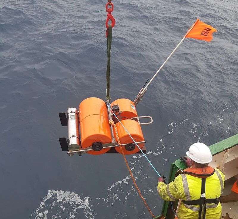
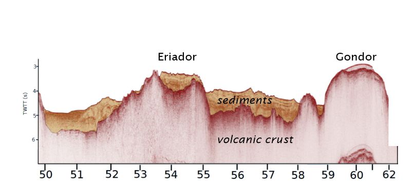
That evidence was gathered from the seabed below the stormy waters of the North Atlantic in May 2021 by scientists from the UK, Ireland, and Denmark. They recorded a 400-kilometer-long cross-section through Earth’s crust created using shockwaves in the ocean made with compressed air and recording the echoes of those shockwaves reflected off layers of rock within the crust to make a “seismic section.” That technique doesn’t penetrate deep enough to image the whole crust, so they also deployed special microphones onto the seabed, called “ocean bottom seismometers,” to record vibrations that traveled through the lower part of the crust. When the two kinds of seismic scans are combined, they show the layers of seabed sediment draped over volcanic rocks, and they show how thick that volcanic crust is above Earth’s mantle.
Baked crust
Thicker crust indicates the mantle was hotter when that crust formed: “If it’s really hot, more stuff is going to melt, then that will be erupted and solidified to form thicker oceanic crust,” said Knight.
And, because the crust in the seismic section is younger in the west and older in the east, it provides a record of the mantle’s temperature change over the time leading up to the PETM and afterward. It shows a big bulge of thick crust, named the Eriador Ridge, that matches the time of the PETM, and supports the idea that a pulse of hot rock occurred at the right time to trigger the climate event.
The real value of the work, however, will come once the dates along the line of the seismic section are refined using magnetic data that the 2021 expedition recorded: “this will be really, really precise aging because it’s exactly along the [seismic] profile,” said Knight.
Those precise dates will tell the team how quickly the hot mantle pulse mushroomed away from where it initially breached the crust—near where Iceland is today—out to Eriador Ridge 700 miles (1,000 km) away. “It took some time for this pulse to spread out, and the rate of that is… another really important thing for our estimates of how fast the carbon was released,” said Knight. “If this pulse spreads out really slowly, the same amount of carbon will be released over a long time; versus if it spreads out really fast, all of that carbon will be released very quickly.”
The significance of this is that up till now, the amount of carbon released to generate the PETM has been calculated from the aftereffects of the emissions—things like changes in ocean chemistry recorded in fossils of plankton that lived at the time. But Knight’s colleagues at the University of Birmingham will be able to approach the calculation of emissions from the other end, working out how much CO2 was actually emitted by the lavas and the magma-baked sediments.
“We’re estimating carbon release directly from the source rather than estimating carbon released from the effect it had on things that have been changed,” explained Knight.
https://arstechnica.com/?p=1909428

