Coastal denizens of the US Pacific Northwest are (or should be!) familiar with the significance of “the Big One”—a major earthquake just off the coast that will occur someday. The tectonic plate boundary, where oceanic crust slides downward beneath the North American continent, is capable of producing major shaking and an incredibly dangerous tsunami. This hasn’t happened in centuries, leading to a false sense of security, but the evidence is there for events deeper in the past.
But the plate boundary itself isn’t the only source of seismic danger. Near Portland, for example, there are a number of smaller active faults. There have even been moderate earthquakes in recent years to serve as reminders. In 1993, a magnitude 5.7 quake just 50 kilometers (31 miles) south of the city caused around $30 million in damage. Here, too, seismologists can look deeper into the past. And it shows that much bigger earthquakes are possible.
Forensic seismology
Today, we measure and quantify earthquakes with seismometers, but it’s possible to find physical evidence that testifies to past earthquakes. Paleoseismology relies on the fact that some things move during an earthquake, displacing their position. In the right situation, you can even see about how much the fault moved and put a date on each event. That allows for a rough estimate of earthquake magnitude, as well as the average time between major earthquakes. (Note that this does not mean we can predict the date of the next one. Earthquakes are not clockwork events.)
Where the oceanic crust dives beneath Oregon, the two plates are obviously colliding. But looking at the West Coast itself, the tectonic forces are a little more complex. The continent is actually rotating a bit, such that Oregon is sliding to the north-northwest a bit as it collides with the oceanic plate. Washington is actually doing this a little more slowly than Oregon, creating a traffic-jam-squeeze in the middle.
Portland sits in a flat basin, with northwest-oriented faults where it meets the rugged terrain of the Coast Range. Those faults tend to experience compression as well as lateral movement due to the combination of tectonic forces. Long-term fault movements often leave an unambiguous, linear mark on the landscape, though the prodigious moisture and vegetation in this area do a pretty good job of obscuring things. Still, some of these faults are identifiable on the landscape if you know how to look.
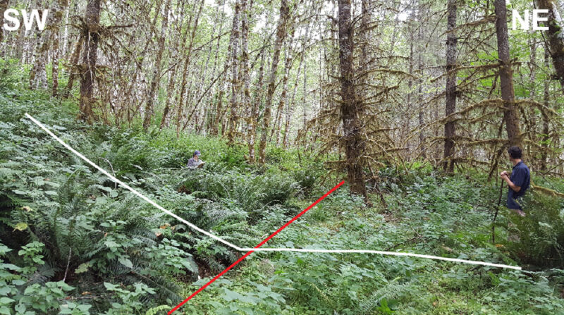
That includes the Gales Creek fault 35 kilometers (22 miles) west of Portland. A Portland State University team led by Alison Horst set out to dig a small trench across this fault to examine its history. Because it’s identifiable on the landscape, it has been assumed to be an active fault, but little was known beyond that. By trenching across the fault at the surface, the patterns of sediment and soil can reveal movements during past earthquakes. Find a few bits of organic material in there, and carbon-dating can even tell you when they happened.
Reading between the lines
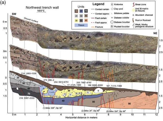
After digging across the fault, some layering in the soil jumped out at the researchers. Alternating colors and sediment contents highlighted unusual patterns, like a top soil layer buried beneath the current top soil—which can happen when fault movement opens up a space that gets filled in by sediment. One layer also contained a jumble of cobbles that appear to have rolled downslope during earthquake shaking.

There were also fine, vertical faults disrupting these layers. And this is where the geologic deduction kicks in. If a fault breaks through one layer but stops at the base of the next layer up, that top layer must have been added after the fault event. By using these spatial relationships, the researchers identified three different earthquakes. Carbon-dating of bits of forest fire charcoal in between each of those earthquakes puts them at about 1,000 years ago, 4,200 years ago, and 8,800 years ago. So on average, there was around 4,000 years between major earthquakes on this fault.
It also appeared that the fault had moved around one meter during an earthquake. This is all roughly consistent with estimates based on things like horizontal offset in streams that cross the fault. Those estimates put average earthquake occurrence at around 3,000 years and 1.7 meters of movement. If the whole 73-kilometer-long fault moved during one of these earthquakes, it would have a magnitude of 7.1-7.4. It’s possible that only portions of the fault have moved in each event, resulting in a smaller magnitude. That could be tested by digging more trenches like this one and looking for differences between them.
The takeaway here is that this fault is very much active and capable of a major magnitude 7 earthquake. And it’s not the only fault in this area. Major earthquakes can be rare enough that the true risk is more significant than the events we have experienced, requiring us to discover and learn from prehistory. For Portland, that includes more than just the big offshore earthquake everyone worries about.
Bulletin of the Seismological Society of America, 2020. DOI: 10.1785/0120190291 (About DOIs).
https://arstechnica.com/?p=1716859

