

During the 1950s and 1960s, US spy planes made regular flights across Europe, Central Asia, and the Middle East, photographing the terrain to track military targets. A chunk of the Middle Eastern photographs were declassified in 1997, and now those airborne images are helping archaeologists track changing features in the landscape that in many cases are no longer visible today, according to a new paper published in Advances in Archaeological Practice.
Co-author Emily Hammer is a landscape archaeologist at the University of Pennsylvania, meaning she studies how humans in the past were organized with respect to their environment and landscape: where people were living, where their roads were, where their irrigation canals were, and so forth. But it’s not always possible to see more large-scale features on the ground, so aerial photos and satellite imagery are a critical tool for landscape archaeologists.
“[It] lets you stand back and see larger patterns that tell us about how humans relate to their environment in the past.”
“It’s like an impressionist’s painting,” said Hammer, in that there is no discernible pattern when viewed up close. “Just like stepping back from the blobs of paint on an Impressionist painting reveals the full picture, [aerial and satellite imagery] lets you stand back and see larger patterns that tell us about how humans relate to their environment in the past.”
Hammer and her co-author, Jason Ur of Harvard University, had previously studied images from the CORONA spy satellite program that ran from 1959 to 1972, but the resolution in most of those photos wasn’t good enough to capture the features they were most interested in. Then a Chinese colleague mentioned he had used U2 images of his village in China, with much better resolution for archaeological purposes. That launched several months of tedious detective work, since none of the images had been indexed or scanned.
They painstakingly unspooled rolls of film over a light table to pick out frames of interest. Then they photographed the negatives incrementally and pieced together each frame. The final step: georeferencing the images with GIS software to ensure their image dataset matched real-world coordinates.
Interesting archaeological features captured in the images included a canal irrigation system in Northern Iraq and prehistoric stone-wall hunting traps called desert kites, which were used to trap animals like gazelle over 5,000 years ago. The kites were preserved for a very long time because of the dry desert environment, but as modern agriculture expanded into the region, the kites were destroyed. The old U2 plane images captured many when they were still intact, giving Hammer and Ur an excellent birds-eye view of an ancient hunting tool.
-
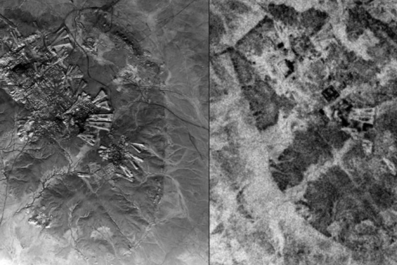
Example of a high-resolution vertical U2 photograph taken over Aleppo, Syria on November 19, 1959.E. Hammer and Jason Ur.
-
Chains of desert kites (hunting traps) visible in U2 imagery taken January 30, 1960.E. Hammer and Jason Ur.
-
The canal system, from northern Iraq, provides insight into how an early empire maintained its power and governed.E. Hammer and Jason Ur.
-
Locations of features and desert kites (hunting traps) mapped using U2 imagery over eastern Jordan.E. Hammer and Jason Ur.
-
U2 images of southern Iraq present the layout, size, and environmental position of Marsh Arab communities in the late 1950s and early 1960s.E. Hammer and Jason Ur.
On a more recent time scale, the U2 images preserved landscape information about the Mesopotamian marsh villages in Southern Iraq, whose inhabitants used to live on floating islands of reed, herding water buffalo and fishing. The villages were destroyed as hydro-electric dams were built in the region and when Saddam Hussein drained the marshes in the 1990s.
Although the marshes are currently being rehabilitated, “Even if the environment itself is recreated, what has been destroyed and will never be recreated is a way of life that had existed for thousands of years in this very unique environment,” said Hammer. There are CORONA images for this region prior to Hussein’s drainage, but the low resolution doesn’t reveal much detail. “With the U2 photographs, we can see and count individual reed huts,” she said. This could help resolve ongoing debates about exactly how many people were displaced during the drainage project.
Thus far, their index includes only the Middle Eastern flights of U2 planes that have been declassified, but the planes also flew over China, Eastern Europe, the former Central Asian Soviet Republics, parts of South America, and Cuba. If and when those photographs are declassified, they can be easily added to the data set. “We paved the road for creating an index for other areas of the world,” said Hammer. “People who are interested in the history, archaeology, and environmental change in the Middle East can use the index we have created to identify the photos that cover their area of interest.”
Hammer is currently doing field work at two early Mesopotamian cities: Ur and Lagash. Ur used to sit right along the Euphrates River, but it’s now located 15 kilometers away in the desert because the river’s path has shifted over time. The U2 photos are useful to help track the shifting position of the Euphrates River, along with analyzing soil samples and pottery fragments excavated from the site. Modern Iraq is a desert that relies on irrigation to grow crops.
For a long time, historians and archaeologists thought that early cities in the region also relied on irrigation for their agriculture. “But in the past, the Persian Gulf extended further north than it does today, and so did the marshes of southern Iraq,” said Hammer. “So there’s a good possibility that these cities were located in the middle of a marsh. They were in a wetland environment, not a desert environment.”
DOI: Advances in Archaeological Practice, 2019. 10.1017/aap.2018.38 (About DOIs).
https://arstechnica.com/?p=1489405