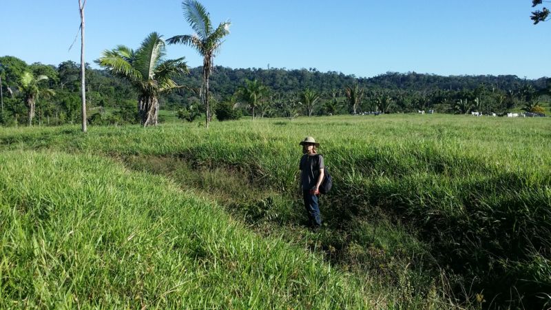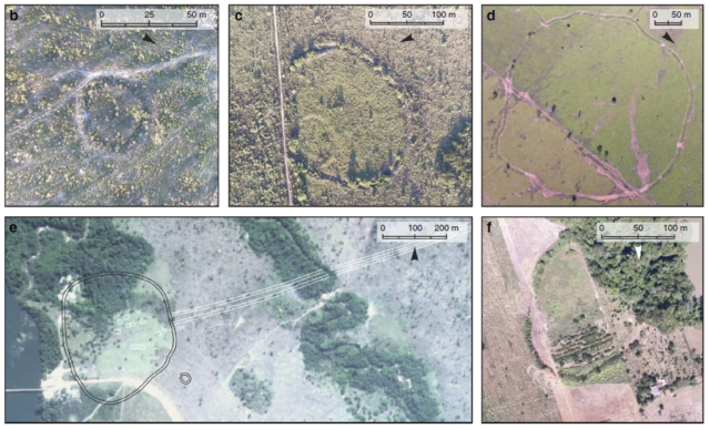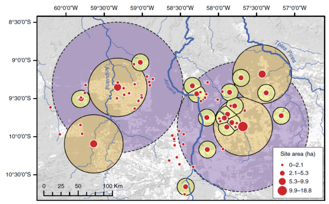
A team lead by University of Exeter archaeologists Jonas Gregorio de Souza and José Iriarte used free satellite images on Google Earth and Zoom Earth to survey 54,000 square km of remote forest in the upper basin of the Tapajós River in Brazil. In cleared spaces where they could get a clear view of the ground, the satellites revealed a surprising number of ditches and earthen walls that once surrounded indigenous villages and urban centers prior to the arrival of Europeans: 104 earthwork structures at 81 sites.
The discovery of so many new sites in a previously un-surveyed area may mean that earth-building cultures were much more extensive and much more densely populated than archaeologists suspected.
Fortified towns left abandoned
Today we think of the Amazon as a pristine rainforest, sparsely populated by indigenous communities. But in records from the 1500s, Spanish colonizers describe a densely populated region, crisscrossed by canals and sunken roads and dotted with bustling, fortified towns. Unfortunately, fortification couldn’t protect the towns’ inhabitants against European diseases, which devastated South American indigenous populations and left the fortified villages abandoned.
The earth-builders left behind deep ditches, earthen walls, raised fields, and canals across a swath of land stretching from Bolivia to eastern Brazil. In the Llanos de Moxos savanna of Bolivia, circular ditches surrounding graves and domestic debris are all that are left of the palisaded villages described in Spanish accounts. Further east, in the Brazilian state of Acre, ditches and walls form complex geometric patterns called geoglyphs, which were probably once important ceremonial centers. Nearby, ring-shaped earthen mounds mark the former sites of villages. And on the other side of Brazil, in the valley of the Upper Xingu River, multiple ditches once enclosed large fortified settlements, linked by roads and causeways.
These earthworks seem to be the traces of several distinct cultures that reached their heyday from 1250-1500 CE, each with its own architectural style and its own style of ceramic artifacts. Today, the southern rim of the Amazon basin is one of the most linguistically diverse areas in the world, and it’s likely that the pre-Columbian earth-builders probably also spoke a variety of languages. But they shared some common threads in their settled, agricultural way of life and their construction of earthworks.
“We believe the shared practice of building ditched enclosures is an evidence of interaction between all these cultures in the southern rim of the Amazon,” said Gregorio de Souza. “Each region has a particular ceramic style, but they all shared a similar architectural tradition.”
Archaeologists have long speculated that the whole southern rim of the Amazon basin may have one long stretch of earth-building cultures, each interacting with its neighbors. That’s been hard to test, though, because most of the rainforest has never been surveyed by archaeologists, especially in the areas that lie between the smaller tributaries, like the Xingu and Tapajós, that flow into the Amazon. The Upper Tapajós Basin, just west of the Xingu, has been an especially large gap in our knowledge of the region, which is why Gregorio de Souza and his colleagues conducted their satellite survey.

The 81 new sites range from small, circular, ditched enclosures just 20m wide to fortified villages over 400m across. About a third of the sites were the smaller variety, surrounded by circular ditches with gaps that look like entrances. Archaeologists have found similar structures a bit further west, in the upper basin of the Xingu River, and they’re thought to be the sites of communal houses for extended families or homes for very high-status individuals like priests or chieftains.
And about 20 of the sites seem to have been large settlements, their locations now marked by roughly hexagonal ditches, one to three meters deep, with embankments standing a meter high on both sides. At the largest of these sites, multiple earthworks coexisted in complex combinations, as if the occupants had added on and remodeled their fortifications over several generations.
“There are historical accounts of large villages in the Tapajós headwaters, and we believe the sites we found may be the archaeological remnants of those,” said Gregorio de Souza. Those accounts describe a densely populated region, with wide, straight roads connecting the villages. Gregorio de Souza’s team found a few sections of roads radiating out from the larger settlements.
At a site called Boa Vista, on a small plateau overlooking the Aripuaña River in the eastern half of the Tapajós Basin, a sunken road framed by two earthen banks runs about 1.5km east from a 390-meter-wide ditched enclosure. And more sunken roads radiate in several directions from a ring of earth mounds that once surrounded a village west of the Juruena River.
It’s not clear whether those roads ever connected to more distant villages or if they served some other purpose. “So far, the only place where a network of roads connecting fortified settlements was found is the Upper Xingu River,” explained Gregorio de Souza. “The roads found in other parts of southern Amazonia, in the [Acre] geoglyphs or in the sites we surveyed, stretch for long distances but do not connect one site to another, as far as we know.”
Who were the earth-builders?
But what we don’t know, for the Upper Tapajós Basin or any of the other Amazon earthworks, is exactly who the builders were or how they’re related to today’s indigenous communities.
“Most of the areas where the earthworks are found are no longer inhabited by indigenous groups,” said Gregorio de Souza. “The groups that are still inhabiting the surrounding [areas] belong to all major language families of the Amazon, but it is difficult to connect the earthworks to one or another.”
The Upper Xingu River basin, east of Gregorio de Souza’s survey area, is an important exception. There, Arawakan-speaking communities still live in large circular villages linked with a network of roads, which look a lot like what archaeologists say pre-Columbian earth-builder villages would have looked like—except that the modern villages are smaller and not fortified.
Whoever the Upper Tapajós Basin earth-builders were, their society seems to have been fairly complex. The smaller enclosures are clustered like satellites around the larger settlements, and Gregorio de Souza and his colleagues say that looks similar to modern indigenous communities in the nearby Upper Xingu Basin. Each village is politically independent, but the largest ones are ritual centers and wield a sort of informal social prestige.

The Upper Tapajós Basin earth-builders had developed their own architectural style, and ground surveys at a few of the sites reveal that they had a unique ceramic style as well. Their inhabitants seem to have borrowed some familiar elements from the cultures to their west and east, including the people of the Upper Xingu Basin. That means there was probably some interaction between them, which supports the idea of a continuous network of earth-building cultures stretching across 1800km of the southern Amazon basin. And that means human impact on Amazonian forests may have been much more intense than previously suspected.
“Nowadays, we know that the image of Amazonia as an untouched forest is certainly wrong,” said Gregorio de Souza. “However, because there is so little research in most of the Amazon, we don’t know to what extent that is true of the whole basin. The more we survey, the more we realize that human occupation, and consequently environmental impact, was higher than previously thought.”
Modeling pre-Columbian populations
To help answer that question, Gregoria de Souza and his colleagues used their survey data, along with the locations of previously discovered sites, to create a computer model of the probable extent of earthworks along the southern rim of the Amazon Basin. The algorithm they used was developed by ecologists to model the possible range of a species based on the places it’s already been seen, although archaeologists have recently used the algorithm to predict the locations of geoglyphs, maize fields, and other archaeological sites. For each earthwork site, the archaeologists included several variables, such as altitude, distance from the nearest river, and information about rainfall and temperatures.
The algorithm predicted that earthworks should turn up over a roughly 435,000 square km area of the Amazon Basin. Since the satellite survey found a site about every 300 square km, if that holds true for the whole modeled area, there should be at least 1,304 earthwork sites along the southern edge of the Amazon. If all of those sites were occupied at the same time, the pre-Columbian population of the Upper Tapajós Basin alone could have been over 21,000 people, with about one person per square km.
In the centuries just before the arrival of Europeans, Gregorio de Souza and his colleagues wrote in their study, “the whole southern rim of the Amazon was settled by dense populations living in fortified villages.” The researchers estimate that the area may have been home to between 500,000 and one million people.
And since the southern rim of the Amazon makes up just seven percent of the whole Amazon basin, the team says their study “definitively discredits early low estimates of 1.5 to 2 million inhabitants for the whole basin,” a claim which is likely to spark some debate among archaeologists. Of course, this isn’t the first time recent surveys have indicated pre-Columbian cultures were more extensive than we previously supposed.
More discoveries are waiting
The archaeologists trekked into the forest to survey 24 of the sites from the ground, and they conducted more thorough excavations at the largest, dubbed Z-Mt-04, which combines two of the largest ditched enclosures into a single 19-hectare compound. There, they found ceramics, stone tools, and a thick layer of distinctive fertilized soil called Amazonian Dark Earth. Charcoal from the earliest layers at the site dates to between 1410 and 1460 CE.
If Gregorio de Souza and his colleagues are right, archaeologists have only found about a third of the sites in the southern Amazon Basin so far, with nearly twice as many still out there in the rainforest waiting to be discovered. Satellites will be an important part of finding them, and Gregorio de Souza says they’ll need to turn to lidar to penetrate the dense rainforest canopy that may be hiding a lost culture. In the meantime, there’s more work to be done on the ground.
“We plan to return to the Tapajós headwaters and excavate some of the largest and most elaborate sites in order to understand the different phases of construction and whether they were occupied by different cultures through time,” said Gregorio de Souza.
Nature Communications, 2018. DOI: 10.1030/s41467-018-03510-7 (About DOIs).
https://arstechnica.com/?p=1284325

